A few candid shots.
Go to www.photobucket.com/albums/aa209/Dougknox
Clinton Mile 264
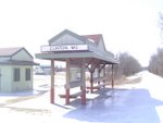
The beginning
Machens Mile 27
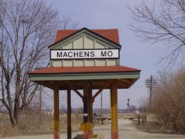
The goal
Friday, July 20, 2007
Monday, July 9, 2007
Medical Update
My foot is still swollen, discolored, and painful after finishing the trail 3 weeks ago. I broke down and went to the Podiatrist to find out I had a badly broken toe. The foot started hurting about 3/4 of the way through the hike, I just thought it was from all the pounding. Evidently it was a stress fracture that splintered because I kept walking on it. Now I've got a funny blue shoe instead of my hiking boot. He said stay off of it for 3 weeks, like that's going to happen.
Friday, July 6, 2007
A few final thoughts
Receiving the rest of my pictures from the trip gave me cause for reflection of the history associated with the Katy Trail, overall impressions of the trail, and what my trip really meant to me.
One of the first things you’ll notice along the Katy is the telegraph line that parallels the trail. It’s quite daunting when you think of all the history that passed through those telegraph lines since the inception of the Missouri-Kansas-Texas railroad in the late 1800’s. These lines brought news of the admission of new states such as Wyoming, Utah, and Colorado, word of the assassination of President McKinley or the start of the Spanish-American War in Cuba. Even news of Kodak’s first portable camera, or the refrigerator!
My thoughts turned to the early explorers like Jacques Marquette, the French explorer who traveled up the Missouri and the Indian tribes, many now extinct, he encountered along the shores of the river while exploring the Mississippi River. I passed many historical markers concerning the Lewis & Clark expedition. The flow and course of the Missouri has changed since then but you can still see the bluffs and wonder what Lewis & Clark thought when they first encountered them. Parts of the Katy still allow you to actually follow in the footsteps of the expedition. You’ll see signs telling of land grants to such American legends like Daniel Boone while the land still belonged to the Spanish. Part of the Katy includes pieces of the Santa Fe Trail, which opened the west to thousands of settlers.
I have to mention the Boonville Bridge. The rail bridge has a section that would actually rise up to allow steamboat and barge traffic up and down river. This is a site you must see to appreciate. It just wouldn’t have the same impact on you if you only saw it in pictures. God I hope they can prevent the potential destruction of the bridge.
You’ll see landscapes that vary from prairie to river valleys along the trail. The trail itself was very well maintained and made for a very nice backpacking trip with a few exceptions. Camping along the trail is illegal. It can be a long, long, hike between campgrounds unless you stay at B&B’s (Bed and &Breakfasts). Most of the B&B’s are really beautiful and run by exceptional people. This is all well and good but not for a backpacker on a budget. I’d like to see the state make some small, ¼ acre campsites every 15-20 miles. Heck, at least build the small three sided shelters like you see along the Appalachian Trail. I’m glad I was able to make arrangements to stay on private property along the way. The kindness of those property owners saved me twice when shelter or campgrounds were at least 25 miles apart or non-existent like the 40-mile stretch from Augusta to Machens. Water is another story entirely. Mentioning the lack of water along the Katy has been discussed so many times by others that it’s like beating a dead horse. I hid two gallons of water along the trail on my way to Clinton. This saved me from having a serious survival issue on my hands twice. I had iodine purification tablets with me but it’s still hard to find a stream with semi-clear water to treat.
It’ unrealistic to expect the Department of Natural Resources to spend the money needed to provide water at every trailhead. Plan ahead and make your own water drops. And please, pack your empty water jug with you to the next trailhead for proper disposal. I am also considering packing a lightweight umbrella the next time for shade. The sun was brutal and sometimes any shade would have been a welcome relief. Maybe it will be a kid’s Cinderella umbrella, there’s a conversation starter. I also learned later in the hike that it’s a good idea to liberally spray the clothes you’re putting on the next day with insect repellent. Just spraying your skin only seemed to antagonize the mosquitoes.
There were some days I wouldn’t pass anyone along the trail for 8 hours, and then it may only be a hello to a passing bike. Certain parts of the trail are ideal if you “want to get away from it all”. The people you do meet however are the friendliest, nicest, most honest, helpful people you’ll ever encounter. Like Cath at the Hartsburg Inn. I arrived after a brutally hot, dusty, 10-hour hike. She didn’t take Visa and I was about $5 short for the price of the room. Her response was “mail me the balance when you get home”. How often do you encounter that in this day and age? Or the farmer cutting grain along the trail that stopped his tractor so I wouldn’t get covered with dust as I passed by. There’s always a wave from passing cars and nice long relaxing conversations with bicyclists along the way. I met people from as far away as Alaska and San Francisco and as local as the next town. I will certainly never forget the people from a certain church who were beyond accommodating when I camped on their property. Everyday the news reminds us of the evil in the world, which makes us take a cynical outlook on others and an overall lack of trust in people. The Katy will cure that. You’ll learn that there are still a lot of good people left in the world. People you meet on and along the Katy really seem to bring out the best in each other. Not to sound Zen but I really believe I found myself out there. I like the guy I used to be, it’s nice to be him again.
A word of advice to other backpackers: Remember the 5 P’s: Prior Planning Prevents Poor Performance. Drive along the trail prior to your hike and plan those water drops. Talk to property owners along the way who might allow you to pitch a tent overnight (8 hour maximum) on those long stretches between campgrounds. Make reservations as far in advance as possible if you must stay at a hotel. I learned that lesson the hard way in St. Charles during the Southern Baptist Convention.
I regret that one time I was so intent on reaching my next stop due to heat That I didn't pay attention to the scenery. I'll re-hike that section another time.
Would I do it again? You’re darn skippy!! Maybe next time I’ll travel east to west. Then again, I’ve been reading about the 500-mile Ozark Trail that runs from Missouri to Arkansas. Hmmmmm……..
P.S. I'll be posting some of my pictures shortly.
P.S.S. Don't ever forget: Hikers rule and bikers drool (just a joke, sorry Mary). See you on the trail.
Wednesday, July 4, 2007
Machens
Someone asked me if going through the high grass, chiggers, ticks, and no shade at the end of the trip was really worth the hassle to reach Machens. Hmmmm, let me think. I might be alone here but I’ll try my best to answer this for you. My goal was to backpack the entire Katy Trail from end to end. After walking 219 miles with a 30 pound backpack and another 19 with a 12 pound pack, I felt that I couldn’t quit so close to my goal. I didn’t want to hike the roads that parallel the Katy to Machens so I could honestly say that I hiked the entire trail from end to end. Maybe I just viewed the hot, bug infested part between St. Charles and Machens as a gut check to see how bad I wanted to reach my goal. I didn’t think that overcoming adversity to reach a goal was a bad thing. It gave me a greater feeling of accomplishment when I hit mile marker 27 and the end of the trail. In regards to the restroom. It was new and an improvement to the EOT (end of trail) indicating they were starting to make improvements to that end of the trail.
Would I do it again? I'll answer that in my next post: Final Thoughts.
Would I do it again? I'll answer that in my next post: Final Thoughts.
St. Charles to Machens
St. Charles to Machens is an odyssey. The first thing you need to do is go to a sporting goods store and buy a pair of the cheapest, non-cotton , lightweight convertible pants they sell. You’ll need both long pants and shorts for this stretch, making them convenient. As you go under Interstate 370 you’ll come to the end of the “established trail” because it turns into a dirt path that looks like it may have been a service road at one time. Stop here and put the legs on your convertible pants and bug juice up. Follow the dirt road; you’ll see bike tracks. Next you’ll come to a fork in the road. Bear right, it looks like you’re back on the Katy and you’ll go around a nice little pond. After the pond the road bears right back onto the dirt path. The grass here is knee to mid torso high. There were chiggers and ticks so the bug spray pays off. I even saw Jake the Snake twice so you really have to watch your step. The path alternates from crushed limestone to dirt to big rocks and back to dirt numerous times, the grass is still high but bearable if you stay on the path. The distance so far would be about 6 miles. You finally dump out onto what we would recognize as the Katy just before mile marker 33 when you hit the trail. Wear a hat, use sunscreen if you want, wear your long, lightweight pants in the grass, and carry lots and lots of water. There is no shade!!! Good news: They have upgraded Machens! There’s an indoor toilet so you can sit down to do your business (#2). No more digging holes for tree fertilization is required.
Greens Bottom to St. Charles
Met Jill at Greens Bottom for a resupply of water and a change of packs. Tomorrow will be my last day so I changed from my 30-pound backpack to a daypack with water first aid stuff, bug spray, and water. Total weight: 12 pounds. You're not allowed to camp along the trail with Machens 18 miles away. I'm going to celebrate at a hotel and nice restaurant tonight since tomorrow is my last day on the trail. My luck held up. All hotel rooms within a 30-mile radius was booked solid thanks to the Southern Baptist Convention. The only room I could find was smoking and $94. In the words of my old friend Mary Daugherty, they can "kiss upon it". My revenge was walking into Applebees wearing clothes that haven't been laundered in 60 miles. It tuned a lot of heads. I hated driving the 30 miles home but didn't have a lot of choice. The hike to St. Charles resumed the next day with my 12-pound pack. It was pretty uneventful; I guess that's normal when you hike certain sections too many times.
The trailhead at St. Charles is really cool. There's an old depot in Frontier Park, it's also the starting place in Missouri for the Lewis & Clark expedition in 1803. Old town St. Charles is really nice.
The trailhead at St. Charles is really cool. There's an old depot in Frontier Park, it's also the starting place in Missouri for the Lewis & Clark expedition in 1803. Old town St. Charles is really nice.
Klondike to Greens Bottom
Pretty uneventful since I've hiked this part of the trail at least 20 times. Pack a lot of water because there aren't any water stops until St. Charles, 24 miles away. I had a nice rest 10 miles down the road at the Weldon Spring trailhead. Weldon Springs claim to fame is that it used to be associated with nuclear material around the time of WWII. The highest point in St. Charles County is located here. It's this huge concrete pyramid that seals uranium buried deep underground. There's no water at the Trailhead and no way I would even drink treated water from those streams. There's not enough iodine and chlorine in the world that would make me touch that stuff.
I felt proud when I looked at the trail map at the kiosk and realized how far I have actually walked. It was a real motivator. Today's hike was another 20 miler when I got to Greens Bottom.
I felt proud when I looked at the trail map at the kiosk and realized how far I have actually walked. It was a real motivator. Today's hike was another 20 miler when I got to Greens Bottom.
Klondike
I stayed at Klondike Park the next day for a little R&R. I got up, ate, and hung all the contents of my pack on a clothesline I made. The pack contents were dry but they really needed aired out. Left the line up all day, the Park officials never said a word. I just laid back, read, and generally relaxed. Klondike Park has a lot history associated with it; it's a nice “weekend with the kids” kind of place and well worth the stop. The park is very rocky and really reminded me of the Badlands in South Dakota. You'd never expect to see that in Missouri. I've stayed there many times and really like the place. There's another long hill behind the conference center leading up to a scenic over view of the river. You have to see it to fully appreciate it. There are still a lot of rocks up there but no climbing is allowed. Once I saw a longhaired goat grazing there and just couldn't believe it. I later read on the comment forum at www.bikekatytrail.com that there is a herd of Ferrell goats in the area.
Mile Marker 88 to Augusta
My original plan was to camp at Marthasville. I arrived at Marthasville at 1:00. I had been bedding down for the night at 9: when it gets dark so I really didn't want to hang out for 8 hours. I've been there before so I decided to move on to Augusta. My feet still hurt but always seemed to loosen up about a mile or so into the trip. This would be a 22-mile day to Klondike Park in Augusta (mile marker 64) but I felt confident. Be careful on this leg it's pretty open especially around Nona. The clouds were getting very black in the west. I picked up the pace trying to beat the impending storm. Lots of thunder but no lighting. I was managing to stay just ahead of the storm so I didn't dare stop even though I was exhausted. I reached the trailhead in Augusta at mile marker 66. I had covered 20 miles at a quick pace so I dropped my pack and collapsed on the bench at the Kiosk. It was at that moment that I realized 46 years old was too old for this and I should have done this crap 15 years ago. After 20 minutes I told myself it was only 2 more miles to Klondike and it was over so I needed to go. I felt like I'd just been mugged when I got up. I made it about 20 feet when the rain started coming down in buckets. I went back to the kiosk and put the cover on my pack and my rain gear on. The cool rain was quite refreshing after a long day of hard hiking. I'd hiked this stretch many times but forgot about the big hill going up to the park. This was one of those stop and rest every 10 steps kind of hills. I thought I was going to die.
I made it to the top and grabbed the first campsite I saw. The basic sites have covered picnic table, and a fire pit. I managed to get the tent up and it was nice and dry inside. Here's the trick: Lightweight hiking tents are relatively small. A 2 person actually only holds one person and their pack. I managed to erect the tent on top of the picnic table under cover and merely walk it out to the spot and stake it down. The rain stopped so I walked to the shower house, paid my fee and had a nice hot shower. The hot shower, change of wet dirty clothes for dry dirty clothes and fresh socks, and a nice hot meal of beef stew made me feel like a new man. I hung the food bag, crawled into the tent and immediately fell asleep into a deep slumber.
I made it to the top and grabbed the first campsite I saw. The basic sites have covered picnic table, and a fire pit. I managed to get the tent up and it was nice and dry inside. Here's the trick: Lightweight hiking tents are relatively small. A 2 person actually only holds one person and their pack. I managed to erect the tent on top of the picnic table under cover and merely walk it out to the spot and stake it down. The rain stopped so I walked to the shower house, paid my fee and had a nice hot shower. The hot shower, change of wet dirty clothes for dry dirty clothes and fresh socks, and a nice hot meal of beef stew made me feel like a new man. I hung the food bag, crawled into the tent and immediately fell asleep into a deep slumber.
On the road to Mile Marker 88
Jill dropped me off at Blufton, I was kind of down about leaving the trail yesterday. It was late afternoon so I took a short 5 miler to Rhineland and stayed in the city park. They keep the water on and the restrooms are kept open. There's a very nice designated camping area that's open and flat. A cop came by and waved, he must have just been patrolling. I regret not camping at Steamboat Junction I've heard it's a really nice place. All day I've seen bicyclist going down Highway 94 with vans behind them playing music. They kept coming by all night. Some vans even had spotlights illuminating the road ahead of the bikers. I later found out they were racing across America, coast to coast. These guys ride a minimum of 20 hours per day and usually eat while riding. They're better folks than I am. Rhineland is at mile marker 105 and I had made previous arrangements to camp at mile marker 88. It would be a long day but I guess that's my penitence for wusing out at Blufton. It was a really hot walk but still along the river, making for a very scenic hike. I stayed at a church that's about a mile from the trail that night. The minister used to live about an hour away from the church in Moscow Mills, which is only about 10 miles from my home in Troy. The church at mile marker 88 is one of those quaint, small rural churches that only have services every other week.
The caretaker was a super nice guy. I called him just to let him know I was there. He shows up 5 minutes later to open the fellowship hall so I would have restroom facilities and running water. He even said I could sleep in there if I wanted. The women of the church had a quilt stretched out on a frame they almost had finished. I'm not a big arts and crafts guy but it was beautiful. I filled my water bottles and set up my tent outside, don't want to overstay my welcome. The only requirement was to lock the door when I left. It's refreshing to know there's still good people out there.
The caretaker was a super nice guy. I called him just to let him know I was there. He shows up 5 minutes later to open the fellowship hall so I would have restroom facilities and running water. He even said I could sleep in there if I wanted. The women of the church had a quilt stretched out on a frame they almost had finished. I'm not a big arts and crafts guy but it was beautiful. I filled my water bottles and set up my tent outside, don't want to overstay my welcome. The only requirement was to lock the door when I left. It's refreshing to know there's still good people out there.
Blufton
The first part of the hike to Blufton was really nice. My feet finally stopped hurting about Mokane. Mokane is a very nice trailhead and a nice little town to wander around in. There was a Department of Natural Resources worker at the trailhead that was a nice, polite, funny guy. He warned me about possible mosquito issues down the trail and wanted to make sure I had water and bug spray.
You're right next to the river on the trail to Portland. Nice scenery and a very pleasant trip. There is a nice mowed field with benches as you arrive in Portland. The campground that's supposed to be in Portland looks like it's non-existent. The trailhead is nice but only has a restroom, no water. There's an old abandoned looking white building just up the hill. It looks boarded up from the trail head but isn't. Walk around the front and you'll see it's actually a bar and grill with coolers full of beer and soft drinks. The food selection is super and good. I talked to a guy whose chicken eggs just hatched. His kids thought it was great until they found a snake; now the chicks have taken a back seat to the snake. A really funny guy if you hear him tell the story. The road to Blufton was like something out of a Hitchcock movie. As I walked I noticed a few mosquito buzzing around. I bought some great bug repellant and it seemed to be working. I felt a bite on my back and took off my pack to spray myself back there. My back was black with mosquitoes biting me through my shirt. I looked at my legs. The bare legs were fine but my pants were almost black. The swarm grew with every mile. I had mosquitoes flying in my ears, up my nose, in my mouth, even into my eyes. I couldn't stop so I picked up the pace. I was almost at a jog the last 5 miles; they were relentless until I reached Highway 94. I called Jill on the way and asked her to please come and get me. I admit that I broke the cardinal rule of survival, I panicked. I was dead tired when I reached 94 when the mosquitoes stopped. They were all located at the low, damp portion of the leg from Portland to Blufton. Jill arrived after soon after as it was only hours drive from the house. I value my life so I didn't tell her I was okay and didn't need her to pick me up. Once indoors I wowed and amazed my son by q-tipping dead mosquitoes out of my ears and seeing more dead mosquitoes when I blew my nose. My back was covered with bites. I've camped a lot in the past, including a stint in Panama with the Army. I've never encountered anything like that.
You're right next to the river on the trail to Portland. Nice scenery and a very pleasant trip. There is a nice mowed field with benches as you arrive in Portland. The campground that's supposed to be in Portland looks like it's non-existent. The trailhead is nice but only has a restroom, no water. There's an old abandoned looking white building just up the hill. It looks boarded up from the trail head but isn't. Walk around the front and you'll see it's actually a bar and grill with coolers full of beer and soft drinks. The food selection is super and good. I talked to a guy whose chicken eggs just hatched. His kids thought it was great until they found a snake; now the chicks have taken a back seat to the snake. A really funny guy if you hear him tell the story. The road to Blufton was like something out of a Hitchcock movie. As I walked I noticed a few mosquito buzzing around. I bought some great bug repellant and it seemed to be working. I felt a bite on my back and took off my pack to spray myself back there. My back was black with mosquitoes biting me through my shirt. I looked at my legs. The bare legs were fine but my pants were almost black. The swarm grew with every mile. I had mosquitoes flying in my ears, up my nose, in my mouth, even into my eyes. I couldn't stop so I picked up the pace. I was almost at a jog the last 5 miles; they were relentless until I reached Highway 94. I called Jill on the way and asked her to please come and get me. I admit that I broke the cardinal rule of survival, I panicked. I was dead tired when I reached 94 when the mosquitoes stopped. They were all located at the low, damp portion of the leg from Portland to Blufton. Jill arrived after soon after as it was only hours drive from the house. I value my life so I didn't tell her I was okay and didn't need her to pick me up. Once indoors I wowed and amazed my son by q-tipping dead mosquitoes out of my ears and seeing more dead mosquitoes when I blew my nose. My back was covered with bites. I've camped a lot in the past, including a stint in Panama with the Army. I've never encountered anything like that.
Ahh Tebbets
STAY AT THE HOSTEL!! It's basically a bunkhouse but it's clean and is just beautiful. The best $5 you'll ever spend. There was young couple there who were very nice. Down town Tebbetts basically consists of the Hostel, a church, a bar, and the Post Office. Jim's bar is also a must. The food and conversation were super. Jim keeps a sign in log of all the people passing through to about 2002. They have live entertainment on Kareoke night but you have to wait until the patrons are really drunk to appreciate it. It was a nice respite. Tomorrow I'll embark on a 20 miler to Blufton.
On the road to Tebbetts
Left N. Jefferson today. The view of the capital from the trail is stunning. It was a nice cool day, great for hiking. My feet hurt bad but were better after a 1/2 mile down the trail. Gotta be old age. I met 2 other backpackers on the trail today. These are the first backpackers I've ever seen on the trail. They were going from Hermann to Sedalia and back via Amtrak. The older guy was nice but the younger one was a real piece of work that looked like he just came off the cover of Backpacking Today. He made it a point to convince me that I knew squat about hiking and totally ignorant about the proper equipment essential to all backpackers and how only a total idiot would use the equipment I had. He showed me his pack and gave me the make, model, and year of manufacture of his. Of course it just came out last year. I bet that baby ran him about $500 bucks. Of course my external, aluminum frame pack was all-wrong even though I bought it 2 years ago for $50 bucks. His new water bottles were also the only way to go. Probably $ 15 per bottle. I used Gatorade bottles wrapped in duct tape. Price: about $2 last year. He couldn't believe they were even remotely durable. I mean how was I supposed to know that experienced hikers don't use hiking staffs anymore? I thought mine had a 1001 uses but I guess I was still an idiot. We went our separate ways, the old guy waved, the young one sneered. What a butthead.
North Jefferson
A word of warning to all hikers going from Huntsdale to North Jefferson: Go to the gym and walk on an inclined treadmill as part of your training. It actually became comical when I came to the conclusion that this long constant uphill terrain was somebody’s idea of a cruel joke on hikers. It's amazing how desolate it is when you're only 10 miles away from the state capital. We stayed at the Best Value Inn in Holt's Summit. These people were super nice and very accommodating. They even provide a free roundtrip shuttle service from the trailhead. Nate was bummed out because they didn't have a pool. It's close to a Laundromat and numerous restaurants to choose from. Tomorrow on to Tebbetts.
Hartsburg
Let's just call this the Bataan death march. The "plan" was to make this a short, easy leg of 9.2 miles and relax next to the river. I finally arrived at the campground only to find it covered with silt from the flood. Silt means wet, mucky, and mosquitos. I asked the manager if there were any dry campsites, but there weren’t. I just knew I couldn't stay there. I asked if I could at least get a burger from the camp store. He informed me that he only sold food on the weekend. He was a real nice guy and dug in the freezer for a brat and cooked that up. The manager told me how the river had risen up the 9-foot embankment and dumped 4 inches of water into the store! No biggie, I'll move on to Wilton, only another 5 miles. It could still be a borderline easy day. I arrived at Wilton to find the campground overgrown in waist high grass, looked like tick heaven!!. I walked up the hill to the office and found the owners sitting on the porch swilling beer at 2 in the afternoon. The owners showed zero interest in renting a campsite and had to unlock the door to sell me a small bottle of Gatorade for $1.50. Not to be blasphemes but Jesus Christ. On to Hartsburg, another 4 mile away. It was hot and humid along that stretch of the trail. The sun was relentless on the open stretches and I was pretty much out of water when I arrived. I was emotionally and physically drained when I got there due to the sun, heat, and humidity. Jill called ahead and made a reservation at the Hartsburg Inn for me. The women said she would give me a room for $40.00 since it was empty and knew I would be tired. I showed up and obviously looked like hell from the look on her face. She showed me to the room and asked for the $40.00. I dug out every penny I had only to find I had $38.00! I about "pooped" my pants knowing the next campsite was another 3 miles down the trail at the Hartsburg Conservation area. I was totally exhausted and just couldn't walk another step. She said she'd settle for $30.00 and I could just mail her the balance. As God as my witness I thought I was going to cry.
I felt a lot better after a long cool shower, 3 liters of water, and 3 packs of Ramen noodles. I remember lying on the couch in my room for a minute and woke myself up by my snoring 2 hours later. The Inn is a beautiful, clean, converted house that reminded me of the old boarding houses you see in westerns. The owner Cath is a nice, thoughtful, awesome lady. Jill called the Inn that night and Cath brought a phone downstairs to me. I plan on staying there again when I go back to hiking the trail in short sections again. This is easily a 5 star place with fridge, couch, TV, microwave, coffee maker, and all the coffee, tea, and oatmeal you could consume in the room. Each fall Hartsburg has a pumpkin festival, I'll be there. On to Jefferson City where I'll meet Nate and Jill for a resupply drop and another night under a roof.
I felt a lot better after a long cool shower, 3 liters of water, and 3 packs of Ramen noodles. I remember lying on the couch in my room for a minute and woke myself up by my snoring 2 hours later. The Inn is a beautiful, clean, converted house that reminded me of the old boarding houses you see in westerns. The owner Cath is a nice, thoughtful, awesome lady. Jill called the Inn that night and Cath brought a phone downstairs to me. I plan on staying there again when I go back to hiking the trail in short sections again. This is easily a 5 star place with fridge, couch, TV, microwave, coffee maker, and all the coffee, tea, and oatmeal you could consume in the room. Each fall Hartsburg has a pumpkin festival, I'll be there. On to Jefferson City where I'll meet Nate and Jill for a resupply drop and another night under a roof.
Saturday, June 23, 2007
Huntsdale/Katfish Katy's
Made it in around 7 P.M., long day. Nice people but you can see the Campground really took a beating from the flood. Half the sites were closed because of the high water but I got one on the northside of the levee. I laid out my wet tent to dry in the breeze, ate, and got a spectacular shot of the sun setting over the Missouri. That picture is a keeper! The tent was just getting dry around 8 PM when it started raining again. Got the tent up, hung my food bag from a tree (don't carry enough for me & the animals), and all the other gear inside the tent when the rain hit. Smart move packing the sponge. I was able to dry out most of the tent on the inside by using the sponge. Hey, at least my sleeping pad and blanket are dry. I enjoyed a very quiet night once the rain stopped. I had to look out twice to make sure there were other campers. Nice end to a long, wet, 17 miler.
Rocheport
I'm on the way from New Franklin to Huntsdale and all hell has broken loose. It's pouring rain and I'm soaked. I'm glad I took the extra day at the Roundhouse to rest. I am in awe of the bluffs around Rocheport. The railroad tunnel is a sight that will bring me back soon with my wife and son to enjoy. It looks like Rocheport had a tough time with the flooding. The trail was lined with sandbags and you can see how high the water rose in some places. Still a beautiful town. I arrived at the trail head and changed into some dry clothes. I ate at the little diner across from the trail head. It was super! I only paid $6.00 for a lunch so large I couldn't finish it. What a surprise it was when the door opened and in walks the Boy Scout troop from the Roundhouse! They were trying to get a good day of wet biking in. Greetings were passed, I finished lunch and headed out to Huntsdale and Katfish Katy's.
New Franklin
Finally made it through Boonville to New Franklin and the Katy Roundhouse Campground. I have to admit that I was pretty beat when I got here. Today's walk of 23 miles, coupled with my 20 miler the day before, was too long, too hot, and too inclined. I paid my money, pitched the tent, and had a hearty dinner of Ramen Noodles. It didn't take me long to fall asleep that night. The next day was a rest day because Jill was meeting me to replenish my food supplies. Sometime during the night a Boy Scout troop had arrived a few campsites over and I didn't know it. That's called a good nights sleep. I slept in and took a nice shower in the bathhouse. This is a beautiful campground, lots of history. The remnants of an old roundhouse are still there, I hope the pictures turn out. Jill arrived, dropped off some great snacks and dehydrated food. It started to rain later that night, had zero probems sleeping.
Well it's 7:30 and still raining hard. I packed everything but the tent so I could go as soon as the rain lets up. It's now 9:00 and down to a light drizzle. I thought that if I'm going to be wet I might as well be wet on the trail. On to Hartsburg and Katfish Katy's.
Well it's 7:30 and still raining hard. I packed everything but the tent so I could go as soon as the rain lets up. It's now 9:00 and down to a light drizzle. I thought that if I'm going to be wet I might as well be wet on the trail. On to Hartsburg and Katfish Katy's.
Friday, June 22, 2007
Boonville
I have to laugh about Boonville. It was all uphill and never ending. I really started to question whether moving on past Pilot Grove was such a good decision. I finally got my long awaited descending hill. Lots of friendly people, but man was that a long walk. Crossing over I-70 was a motivator. I've seen the overpass from the highway quite a few times, it was a great experience to be on the bridge watching traffic go by. I stopped at the trailhead and took a long break. The old station here is really neat. I was surprised when the railroad crossing bell started pinging at the top of the hour. I decided to move on to New Franklin since I came this far. The Boonville Bridge was a sight to see. I never thought there could be a railroad bridege that raised and lowered to facilitate barge traffic. I heard they want to tear the bridge down. I hope they keep it, too much unusual history. I 'll be sure and share the pictures and description of the bridge with my history students. On to New Franklin.
Pilot Grove
Pilot Grove is a very nice trailhead. There's a small market across the street that came in handy for a nice cold drink. You can resupply on your water here and read some interesting historical background about this small town posted on the boards on the kiosk. I was going to camp in the city park except I arrived at 1:00. I hate hanging out for 8 hours so I decided to move on to Boonville.
Thursday, June 21, 2007
Night of Day 4
I had permission to camp at the Pleasant Green Methodist Church for the night. I've never camped in a cemetery so this will be different. It was very quiet in this rural cemetery, woke up to thunder and lighting flashes but no rain. Stepped out of the tent and looked North where it looked like one heck of a storm. I heard thunder and saw lighting flashes in the clouds but too far away to see bolts. The local radio station said to take immediate cover. The first thing I did was whip out the cell phone to call Jill and let her know I had made it to the cemetery and call my point of contact (I didn't have the number on me)so someone knew I was there. No signal! I took shelter in my tent. There wasn't any rain or hail but the wind hit about 60 mph, per the radio. The wind really shook the tent but only lasted about 5 minutes. Tomorrow on to Pilot Grove.
Sedalia Day 4
Campground is great. Found a nice shaded area and even provided live entertainment for the entire campground. Winds out of the SW at 11-15 mph. There I am trying to pitch my lightweight hiking tent in a moderate wind. Finally took the tent between 2 buildings, erected it (rain fly and all) and carried it to my spot where I staked it down. Sedalia is a beautiful town, the old Rail Depot is definately a place you should go see. Went from Sedalia to mile marker 211. 18.9 miles. My overnight just pastClifton City is a night I'll remember.
Wednesday, June 13, 2007
Notes from day 2 - 6
FROM DOUG: Stayed in Sedalia on day 2 at hotel. My calves felt like jelly, couldn't walk the one block from the trailhead to Green Ridge Park where I'd planned to camp. Took a cab to Sedalia. Stayed in with both legs propped on ice bags. I really felt like calling the whole thing off. Went back to Green Ridge the next morning to pick up where I'd left off for day 3 (June 6). Walked to Sedalia Fairgrounds. Still needed ice but legs seemed okay. I got a great sunburn! The trail here is long and has a steady mile + incline.
Friday, June 8, 2007
Day 5 - June 8
Tonight Doug is settled in at the Katy Roundhouse Campground - mile 189.1. He has traveled 75.5 miles in his first 5 days - and is one day ahead of schedule. Tomorrow he will hang out at the Katy Roundhouse and I will meet up with him to restock some of his supplies, including another paperback. It's pretty quiet in the evenings and with no t.v. or computer - he's going to be getting in a lot of reading. I will be bringing home some pictures to post from his first few days on the trail.
Monday, June 4, 2007
Day 1 - June 4
Well, Doug hit the trail at 7:40 this morning at the Clinton trail head. The weather was perfect! 70s and sunny. He had 16.6 miles to hike to his first stop, Farrington Park (a little city park that allows overnight camping) in Windsor, MO.
From Doug: 1st part good but not a lot of shade; very sunny. Slow 6+ mile incline from Calhoun to Windsor. Really beat when I arrived; sore shoulders & calves. Next 2 days are 10 milers, good chance to recover.
From Doug: 1st part good but not a lot of shade; very sunny. Slow 6+ mile incline from Calhoun to Windsor. Really beat when I arrived; sore shoulders & calves. Next 2 days are 10 milers, good chance to recover.
Friday, June 1, 2007
Here we go!!!
Change of plans, leaving Monday. My wife will update the blog as I call them in, hope to see you in Machens on the 23rd.
Sunday, May 27, 2007
Why?
Here's the answer to a question almost everyone asks: Why?
The answer actually has 4 parts.
First I want to prove I can do it. I haven't had a major challenge since the marathon in 1996 and basically want to see, as Rocky says, "if there's anything left in the basement".
Second, because very few people have hiked the trail end to end.
Third, I love & teach history. There's a lot of history associated with the Katy.
Fourth , to prove something to my son and former students. I've always preached that you can do anything you want as long as you have a goal and am willing to work hard to get there.
I hope this answers the questions for everyone.
Sunday, May 13, 2007
Quicky
Gas dropped so I grabbed a quick 10 miler. I hiked from Clifton City to Mile Marker 210. Long steady incline heading east. I still need to work out the water dilemma from Sedalia to Pilot Grove.
Saturday, May 5, 2007
Minor setback
I'm faced with a few minor setbacks in hike preparation now that gas is $3.15 a gallon. The closest trailhead is 30 miles away so I'll be doing local hikes on the roads near my home. It's not going to be the same as hiking along the Katy but I guess a hike is a hike for training purposes. I'm also not able to make a day drive to try and answer any unanswered questions about facilities, water, etc. But, as my father used to say: "You need horse sh** to grow a good garden".
Monday, April 30, 2007
15 miler
Hit the trail Sunday. Good hike, went from Treloar to Marthasville and back, adding on another mile at the end for good measure. Using a hiking staff now. Jello calves at the end, sore today. I'm going to do some exercises to improve my calves and try some different pack configurations.
Sunday, April 22, 2007
It's all about logistics
Whelp. Traveled the entire trail by car from Clinton to Machens this weekend. I checked every trailhead to make sure there really was water where the "official map" said there was. I also checked to see if there were any stores that sell water near the "dry" trailheads. I learned the hard way not to trust what the "official map" said about water availability at trailheads in the past. I also checked every campground, park, and side trail to verify its existence. I think I'm ready to go. My next step is to go through my pack again to see where I can lighten up in order to compensate for the extra water I'll need to carry on certain legs. The Sedalia to Pilot Grove leg (26 miles between water sources) will be the hardest.
Thursday, April 12, 2007
The Clinton-Sedalia leg.
I'm planning on hiking the Clinton-Sedalia leg a week from Saturday. This is just about the only portion of the trail I've yet to hike. I'll be experimenting with a few ideas on how to pack things. It looks like 16 on Saturday, 9 on Sunday, and 9 on Monday. Then it's a long sleepy Amtrak ride home.
Sunday, April 8, 2007
Saturday, April 7, 2007
Change of plans
Well crud. It's Saturday, my backpack is ready, I'm excited, but the wind chill is 9 degrees. I doubt that I'll be putting in any distance this weekend.
Monday, April 2, 2007
Time to learn
I'm going back on the Katy this coming weekend. It looks like it will be a 13 miler on Saturday and a 15 miler on Sunday. I hate to admit it but I'll be doing the hotel thing on Saturday night. I really wish we could camp on the trail. The goal of this hike is to apply the lessons learned from my last higher mileage hikes. I'll still be "humping" all the same gear as before (tent, sleeping gear, food, etc.) but no camp out.
Thursday, March 22, 2007
Modified shakedown
Did not complete per schedule. Spent Saturday and Sunday trout fishing with my son. Rested Monday, left on Tuesday. Weldon Spring to Augusta (Klondike Park) went well. Rained most of the night and got very cold, thanks for the accurate forcast weathermen in the area. Next day to Marthasville. Feet torn up, time for new inserts or new boots, stopped at Marthasville, wife picked me up there. Seperated my gear into what I used and what was a pain to carry, chucked a few things and will replace them.
Sunday, March 11, 2007
10 miler
Went from McKittrick to the far side of Rhineland, about 10 miles round trip. Great day, I was surprised that I only saw 2 people the entire time.
Saturday, March 3, 2007
Getting ready for a trial run
I'm going to do a "shakedown" trip during my spring break. My itinerary is:
Day 1: Drop off at Weldon Spring, hike 11 miles to Augusta, camp for the night.
Day 2: Hike from Augusta to Marthasville, camp for the night.
Day 3: Back to Augusta.
Day 4: On to Green Bottom
Day 5: Green Bottom to Machens (if time permits)
This should give me a good idea of what to expect. The mileage will increase each day for conditioning purposes. Granted my pack will be heavier than it will be in June because I have to pack warm clothes but it's the education I'm after.
Monday, February 26, 2007
Subscribe to:
Posts (Atom)